
Spring flooding potential
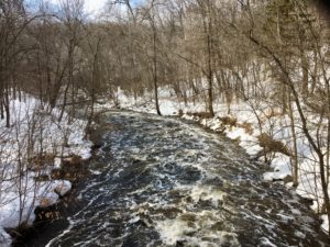 Potential for spring flooding
The major/moderate flooding risk across the Upper Midwest has decreased due to mostly dry weather in February and March. However, with sustained water levels and wet soils throughout the Nine Mile Creek Watershed District (District), and elsewhere in the state of Minnesota, the National Weather Service (NWS) warns that wet spring weather could increase the risk again. Read their March 12 update here.
According to the Minnesota State Climatological Office, 2013-2018 was the wettest six-year period on record. Over those six years, we received more than 30 inches of precipitation than normal. According to the MnDNR, this trend continued again in 2019 with portions of the state experiencing its wettest year on record, with the Minneapolis-St. Paul area receiving roughly 11 inches more than normal.
From the MnDNR: “Extremely wet conditions occurred during the fall of 2019, with September and October each running at least 50% wetter than average over the vast majority of Minnesota. Precipitation surpluses were especially large during September, when over half of the state received at least two times the normal amount of precipitation.”
As a result, shallow groundwater levels throughout the region are at or nearing record highs in the early part of 2020, which is contributing to elevated water levels in many lakes and wetlands. These high water levels have been especially noticeable in lakes that do not have an outlet and have typically maintained their water levels through water loss to groundwater and evaporation. With high groundwater levels, the lakes cannot lose water in this manner, resulting in rising water levels in these lakes.
The District currently monitors water levels on a monthly basis at six shallow groundwater observation wells and 27 lakes throughout the watershed. Water level information can be obtained from the Nine Mile Creek Watershed District by calling 952.835.2078.
Precipitation forecast for Nine Mile Creek watershed
The District recently started working with the NWS to get precipitation forecasts specific to our watershed. The forecasts are made over a 7-day period and are updated every 6-hours.
Access the data here: weather.gov/mpx/nmc
Who should I call if flooding occurs?
First and foremost, make sure everyone is safe in the event of a flood. If an urgent safety situation exists, call 911.
To report flooding in your city, or for specific questions about local flood response, including where to find sandbags and other resources, contact your city.
- Bloomington: Bloomington Public Works, 952.563.8760
- Eden Prairie: Eden Prairie Public Works, 952.949.8360
- Edina: Dave Goergen, Public Works Coordinator, 952.826.0312
- Hopkins: Hopkins Public Works, 952.939.1382
- Minnetonka: Minnetonka Public Works, 952.988.8400
- Richfield: Patrick Martin, Water Resources Specialist, 612.861.9797
What is the District doing?
The Nine Mile Creek Watershed District will continue to:
- provide technical resources to our cities and local partners to help them prepare for potential flooding events and implementing emergency response plans.
- monitor water level elevations throughout our watershed.
- research and invest in resilient solutions to flooding problems, in collaboration with our local and regional partners.
What can I do to protect my property and myself?
Flood insurance can be a good way to protect your property. Flood damage is typically not included in homeowner and renter insurance policies. There is a 30-day waiting period before most flood insurance policies come into effect. To purchase flood insurance, homeowners, renters, and business owners in your community should speak to their insurance agent or call the National Flood Insurance Program (NFIP) Call Center at 1-800-427-4661. The NFIP website provides additional information on the types of flood insurance available, what is covered, and what isn’t covered. It’s important to note that when determining coverage, the cause of flooding matters.
Flood insurance covers losses directly caused by flooding, defined in simple terms as an excess of water on land that is normally dry, affecting two or more acres of land or two or more properties. Damage from groundwater seepage is not typically covered by flood insurance. Talk with your insurance providers to make sure you understand what the policy protects.
In the home, be prepared to deal with spring by being sure you have a functioning sump pump. If you are in an area that may be cut off by flood waters, make sure to have enough food and water in your home to last at least 3 days. Be sure to know your alternate routes if flooding closes roads.
For other useful tips, visit the Federal Emergency Management Agency (FEMA) floodsmart webpage and/or the NWS webpage Flood Safety Tips and Resources.
Flood Safety
Do not swim in flooded waters.
Do not enter moving water or flooded areas – 6 inches is enough to knock a person over or make you lose control of your vehicle. 12 inches is enough to sweep a vehicle away.
Remember “turn around, don’t drown!”
More resources
Actions for a flood resilient home— factsheets from the City of Edina
Hennepin West Mesonet: Extremes of 2019
2020 Spring Flood Outlook update from the National Weather Service
Long range flood risk from the National Weather Service