NWS Spring Flood Outlook updated 3/23

NWS Spring Flood report shows improvement in drought
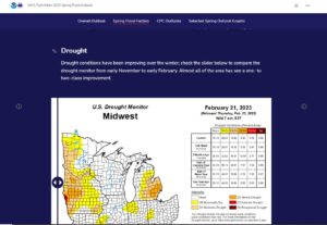
The National Weather Service has updated the spring flood outlook to account for changes due to the latest snowfall. First and foremost, drought conditions have been improving over the winter, especially with the last snowfall. This clip shows a map where you can slide the bar across and compare the drought monitor from November last year, to March this year. Specifically, the Nine Mile Creek watershed has improved four categories, from “extreme drought” to no drought!
Frost Depth
Interestingly, the early snowfall kept the ground from freezing as deep as it normally does, in some cases not even freezing completely beneath the snow! This means that once the melt starts up again, a lot of this snow may soak directly into the soil, rather that running off of frozen ground. This will also help the drought situation tremendously.
Above normal outlook for flooding

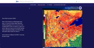
Most of our watershed area had 3-4 inches of Snow Water Equivalent on the ground, due to the record breaking amount of snowfall this year. The map at the right shows the snow water equivalent for the whole state, with warmer colors indicating a higher snow water equivalent.
It is hard to predict flooding at this point in the year, because it still depends on how fast the melting occurs and how much more rain or snow we get in the spring. But, with lake, river, stream, and wetland levels being low going into winter, there is more room for runoff there, which could bring the flood threat down.
All told, spring flood outlook can still be affected by a number of factors, including speed of melt and spring rains, but flood threat is well above normal according to the NWS.
Read the full details at the NWS Story Map
The update on March 23 was the last scheduled update for spring flood outlook 2023.
