
The district has a comprehensive monitoring program to evaluate the health of its waterbodies.
Monitoring Program
Monitoring of waterbodies in the Nine Mile Creek watershed is essential to developing an understanding of past and present conditions within the watershed and determining the need for action by the District or other entities. The District annually implements a lake, groundwater, and stream monitoring program designed to establish baseline conditions, track changes, measure the effectiveness of past and ongoing improvement projects, and inform additional studies (e.g., feasibility studies, water quality studies), as needed.
The monitoring program includes:
• Lake water quality and ecological conditions
• Stream water quality and ecological conditions
• Lake levels
• Groundwater levels
2024 Monitoring Report
The district’s 2024 water monitoring program included monitoring eleven lakes—Anderson Lakes, Arrowhead Lake, Bryant Lake, Lake Cornelia, Lake Holiday, Indianhead Lake, Normandale Lake, Lake Rose, Wing Lake—and Nine Mile Creek.
The following report summarizes the lake, groundwater, and stream monitoring data collected by the district in 2024 and compares this data to historically collected data to assess changes in water quality conditions.
2024 Water Quality Monitoring Report (PDF)
2024 Water Quality Monitoring Report Appendices (PDF)
Past Water Monitoring Reports are found at the bottom of this page.
Water Level Data
Access to lake level and groundwater level data collected by the Nine Mile Creek Watershed District is available on our data sharing site hosted by Barr Engineering: https://maps.barr.com/NMCWD/NMCWD_InformationSharingApp/index.html
The National Weather Service provides a precipitation forecasts specific to the Nine Mile Creek watershed. Get the forecast at: weather.gov/mpx/nmc
Lake Monitoring
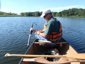
Lakes that are currently monitored on a rotating basis by the district are: Anderson (North, Southwest, and Southeast), Arrowhead, Birch Island, Bryant, Bush, Cornelia, Edina, Glen, Indianhead, Lone, Minnetoga, Mirror, Normandale, Penn (Lower), Rose, Shady Oak, Smetana, and Wing.
Lake water quality is determined by analyzing water samples for a range of parameters, including:
- Nutrients (Measured with elements like nitrogen and phosphorus)
- Chlorophyll a (Measures the amount of algae in a water body)
- Chloride (Typically from road salt)
- Field Parameters (e.g., clarity/transparency, temperature, pH, specific conductivity, dissolved oxygen)
Creek Monitoring
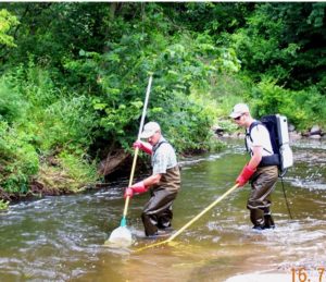
The district monitors Nine Mile Creek to identify problems and any substantial changes in flow, water quality, and the stream’s biological community. The district’s stream monitoring program includes:
- Annual monitoring of the fish community during summer
- Annual macroinvertebrate monitoring during October
- Annual habitat monitoring during the summer
- Storm event related stream water quality monitoring during ice-free season
- March through October monthly measurements of water quality parameters
Data collection occurs at the four permanent, automated sampling stations on Nine Mile Creek. Information is collected on the following parameters:
- Flow
- Precipitation
- Field Parameters (e.g. temperature, pH, specific conductivity, turbidity)
- Chemical water quality, including:
- Dissolved oxygen
- Nutrients
- Chlorides
- Metals
- Solids
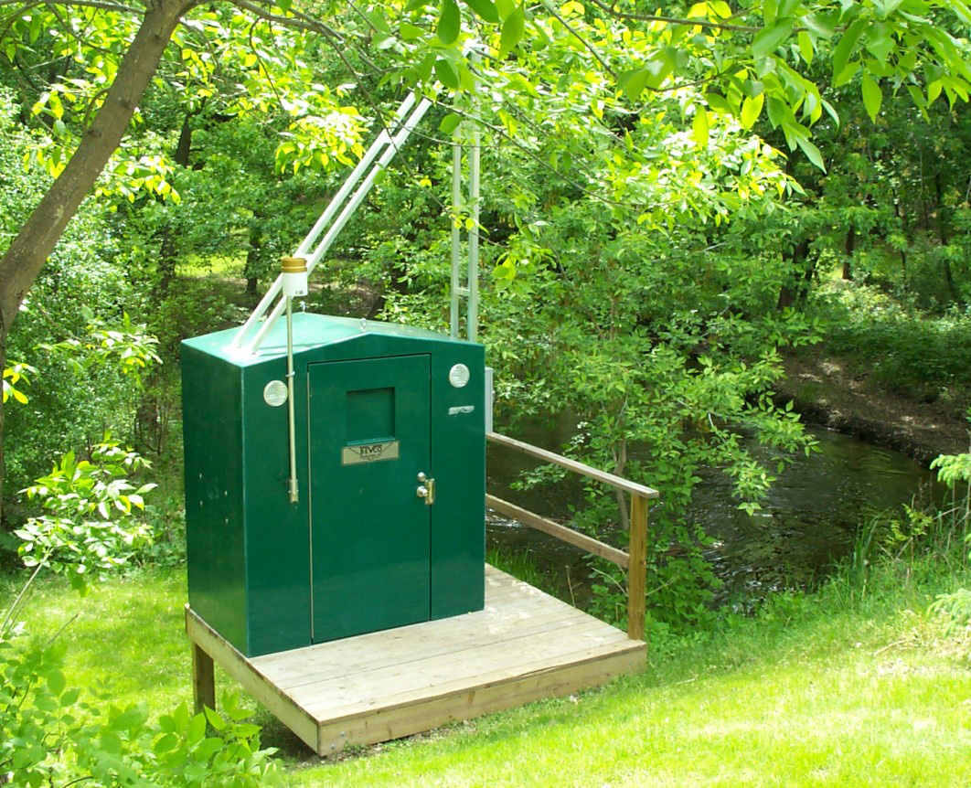 WOMP Station
WHAT IS A WOMP STATION?
WOMP stands for Watershed Outlet Monitoring Program. WOMP stations collect continuous monitoring data year-round. The Metropolitan Council maintains one WOMP station on Nine Mile Creek, while the district operates three sampling stations on the creek.
Groundwater Monitoring
The district monitors groundwater, including the collection of groundwater levels. The district summarizes the data annually and provides the data to the appropriate state agencies. The district will also work with other entities to identify and fill data gaps, including seeking opportunities to increase understanding of groundwater-surface water interaction and understand the impacts of infiltration best management practices on groundwater resources.
Past Water Monitoring Reports
2023 Water Quality Monitoring Report (PDF)
2023 Water Quality Monitoring Report Appendices (PDF, 1,000 MB- available upon request)
2022 Water Quality Monitoring Report (PDF)
2022 Water Quality Monitoring Report Appendices (PDF, 75 MB)
2021 Water Quality Monitoring Report (PDF)
2021 Water Quality Monitoring Report Appendices (PDF)
2020 Water Quality Monitoring Report (PDF)
2020 Water Quality Monitoring Report Appendices (PDF)
2019 Water Quality Monitoring Report (PDF)
2019 Water Quality Monitoring Report Appendices (PDF)
2018 Water Quality Monitoring Report (PDF)
2018 Water Quality Monitoring Report Appendices (PDF)
2017 Water Quality Monitoring Report (PDF)
2016 Water Quality Monitoring Report (PDF)
2015 Water Quality Monitoring Report (PDF)
Water monitoring reports from 2012-2014 are embedded in the district’s Annual Report.
Nine Mile Creek 2014 Annual Report (PDF)
Nine Mile Creek 2013 Annual Report (PDF)
Nine Mile Creek 2012 Annual Report (PDF)
How Can You Help?
Various volunteer opportunities are available for people wanting to help protect water quality in the district or do volunteer monitoring.
Learn more: Volunteer Opportunities