
Watershed-wide
Background:
Adaptive Level Control Systems (ALCS) is a term that is being used to describe smart infrastructure systems such as lake and pond outlets that can automatically change in height to prepare for and manage flood risk. ALCS are used to manage flood risk by raising and/or lowering key outlets in lakes and ponds along a creek system to either encourage water storage or flush water prior to, during, and/or after storm events.
Through its Flood Resiliency and Analysis, NMCWD identified that increasing flood storage along the creek could mitigate flood risk within the watershed. ALCS could allow better management of water conveyance and storage along the creek. However, these systems have historically been used on larger waterbodies like rivers. This Adaptive Level Control Systems Study was ordered by the Nine Mile Creek Watershed District Board of Managers to evaluate the effectiveness of using ALCS in the Nine Mile Creek Watershed. It is a large-scale, dual phased study, in partnership with Barr Engineering and Precision Water Resources Engineering (PWRE) based out of Colorado. PWRE is the national expert in RiverWare Software, a software developed by the University of Colorado-Boulder used to control ALCS.
This study aims to answer several questions:
- Where are the flood “pinch point” locations in the watershed, either hydraulic pinch points like culverts and bridges or locations with significant flood impacts?
- Can we lower water levels of various water bodies either temporarily or permanently, and if so, how much lower?
- Can we temporarily store more water in various water bodies, and if so, under what conditions?
- Can predictive releases of water at various water bodies provide hydraulic advantages to reduce overall flood risk?
- What are the flood risk impacts of adjusting waterflows throughout the watershed?
- What are the flood risk impacts on adjusting water control outlets, in real time, throughout the watershed?
- Where would implementation of ALCS be most effective in the Nine Mile Creek Watershed for flood risk reduction purposes?
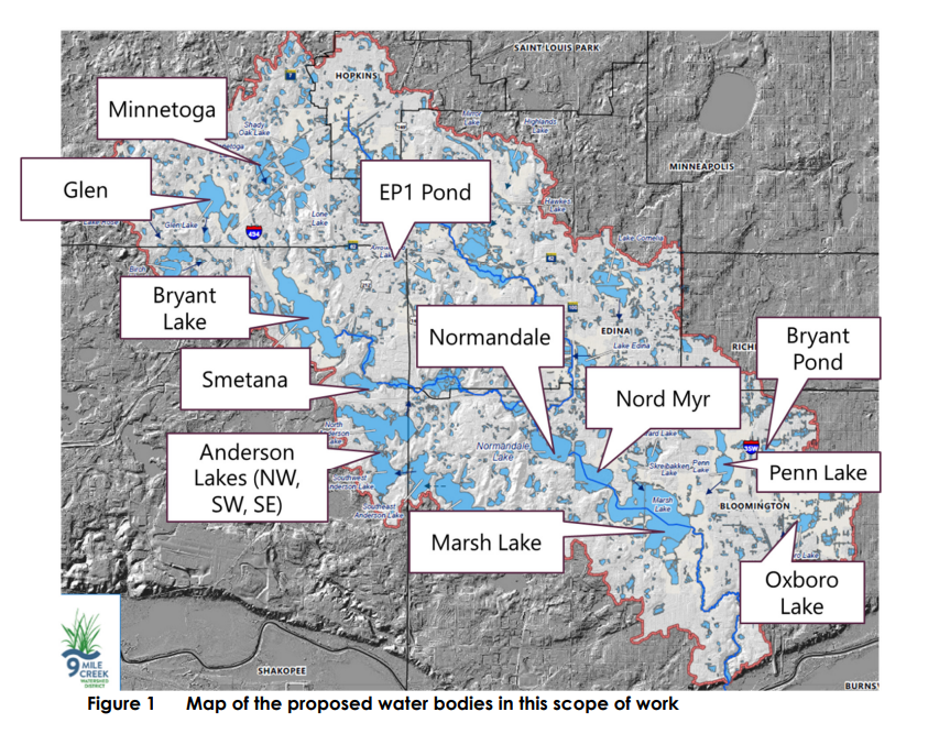
Bryant and EP1 Pond has been eliminated from the study. Nord Myr and Marsh Lake is combined as Marsh Lake. Note: The City of Edina is conducting their own ALCS study in conjunction with NMCWD’s study. The City’s study will review Mirror Lake, Bredesen Park, Highlands Lake, Hawkes Lake, Cornelia Lake, Lake Edina, and Centennial Lakes as potential locations for ALCS.
Scope of Work
The Adaptive Level Control Systems Study is split into two phases:
- Phase 1, has been completed (June 6, 2024): High-level evaluation of ALCS use for the Nine Mile Creek system
- Overview of potential benefits and constraints of ALCS in the Nine Mile Creek Watershed
- RiverWare Pilot Test
- Phase 2, Modeling of the ALCS begin January 15, 2025
- Define potential outlet modifications for the water bodies in the study area
- Define the rules and objectives
- Test the model for hypothetical storm events
- Report and Presentation
Following the completion of both phases, the Board of Managers will decide whether to pursue one or more projects to mitigate future flood events. A feasibility study for such projects is the first step in ordering a project.
Questions? Contact Project Manager Zach Stafslien, zstafslien@ninemilecreek.org 952-204-9690